

Fast Facts
An early-season Pacific storm brought heavy rain and Sierra Nevada snow.
Donner Pass received nearly 12 inches, temporarily closing Interstate 80.
Mammoth Mountain gained up to 13 inches; Yosemite closed several roads.
More storms are forecast, with up to four feet above 8,000 feet.
Sierra Snow Season Spins Up
California’s Sierra Nevada entered the 2026-27 snow season with a fast-moving series of Pacific storms. The first major snowfall of the water year arrived Nov. 13, bringing heavy rain to lower elevations near Sacramento and about a foot of snow to parts of the mountains.
The storm was the opening round in a more active pattern across the West. Rain, snow and strong winds were expected to return in mid-November, putting travel and mountain communities on alert.
A sudden change across the mountains
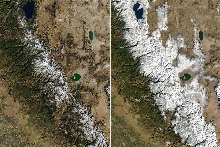
NASA’s Terra satellite captured the shift from space. Its MODIS instrument recorded fresh snow across the Sierra Nevada on the morning of Nov. 14, during a break between weather systems. An image from Nov. 12 showed the mountains mostly bare, with snow limited to the highest elevations.
Ground reports confirmed the rapid change. Nearly 12 inches (30 centimeters) fell at Donner Pass, northwest of Lake Tahoe, on Nov. 13, according to the Central Sierra Snow Laboratory. The snowfall disrupted travel on Interstate 80. Officials closed the highway in both directions that evening.
Farther south, Mammoth Mountain reported 9 to 13 inches (23 to 33 centimeters) of new snow. Yosemite National Park officials closed several roads ahead of the storm.
Early snow can improve conditions for winter recreation, but it can also make travel hazardous before drivers and road crews have adjusted to the season. Snow-covered roads, reduced visibility and wind can quickly turn a routine trip into a dangerous one. Road closures and travel warnings help limit those risks, though they can also delay people and disrupt local businesses.
More snow in the forecast
The National Weather Service issued a winter storm warning for parts of the Sierra above 5,000 feet (1,500 meters) from Nov. 18 to 20. Forecasters warned that travel could become difficult or impossible. Gusty winds were also expected, with as much as 4 feet (120 centimeters) of snow possible above 8,000 feet (2,400 meters).
The developing storm pattern shows why forecasts and satellite observations matter. Satellites can reveal where snow has accumulated across broad, remote areas, while ground measurements help verify depth at specific sites. Neither source tells the whole story alone: local elevation, wind and storm timing can produce sharply different conditions across short distances.
For travelers, the practical choice is to check current forecasts and road conditions before heading into the mountains, then be ready to change plans. For communities, the mix of rain at lower elevations and heavy snow higher up calls for attention to both road hazards and water impacts. The Sierra’s season has begun, but the next storms will determine how quickly its early snow spreads and settles.
Discover More Technology Insights
Dive deeper into the world of Cryptocurrency and its impact on global finance.
Stay inspired by the vast knowledge available on Wikipedia.
Space
