

Quick Takeaways
- Satellites observed melting sea ice and swelling rivers in June 2026.
- Images highlighted vegetation and water features using false-color visualization techniques.
- Saint Lawrence and Nunivak islands showcase volcanic origins and geological diversity.
- Brownish coastal water indicates increased sediment flow from the Yukon Delta.
Emerging Signs of Change in the Bering Sea
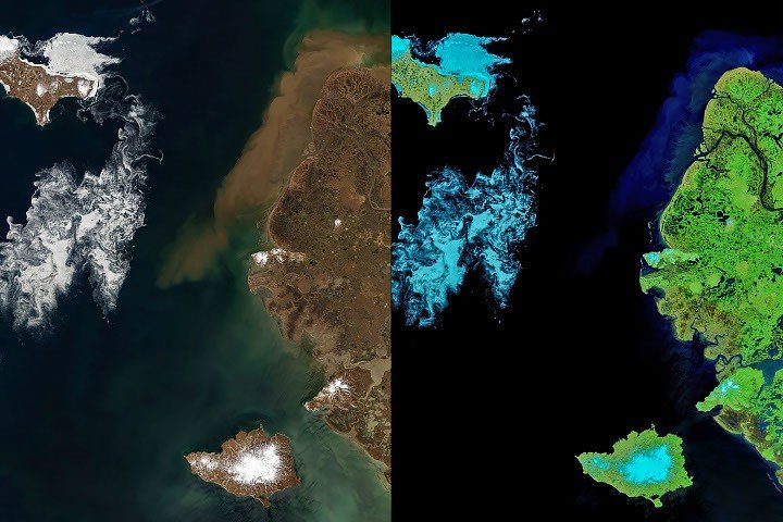
When clouds parted in early June 2026, satellites captured a vivid depiction of seasonal change in the Bering Sea off the Alaskan coast. Images from NASA’s Terra satellite showed a landscape on the brink of summer. Sea ice, now reduced to small fragments, twisted and turned before melting away completely. Rivers, swollen with snowmelt, carried sediment and organic material toward the ocean.
The Moderate Resolution Imaging Spectroradiometer (MODIS) provided two distinct views of this transition. The false-color images revealed details hidden in natural colors. Tundra and marsh vegetation appeared in vibrant green, while ice-free rivers and thermokarst lakes emerged as dark blue. Remaining sea ice and snow appeared dimmer, in light blue tones.
Among these seasonal phenomena, Saint Lawrence and Nunivak islands stood out. Both islands, with their volcanic origins, are significant landforms in the United States. They feature extensive basaltic lava flows and volcanic structures, including cinder cones and maars, the latter being low-lying volcanic craters.
Saint Lawrence Island lies about 150 miles south of the Bering Strait, the waterway that separates Alaska from the Russian Far East. This island is one of the last remnants of the land bridge that once connected Asia and North America during the Pleistocene epoch. In early June, pack ice still lingered along the northeast side of the island. Meanwhile, drifting sea ice spiraled into intricate patterns shaped by wind and currents. The smaller the fragments, the more delicate their swirling designs appeared from a satellite perspective.
The Role of Sediment and Organic Material
The transition into summer also highlighted rivers that discharged sediment into the coastal waters. Brownish water, likely a mix of suspended sediment and colored dissolved organic matter, met the sea near the Yukon Delta. This vast wetland serves as a critical junction where the Yukon River branches out into numerous channels. Sediment concentrations in this area tend to rise starting in late May or early June, triggered by melting river ice and runoff from spring rains and snowmelt.
Understanding the dynamics of this region is crucial. The interplay between river discharge and sediment load plays a key role in shaping coastal habitats. Recent research has emphasized how these factors influence sediment plume behavior in the Bering Sea coastal region. As the climate continues to warm, monitoring these changes becomes increasingly important. The images captured by the MODIS satellite serve not only as a record of seasonal shifts but also as a critical tool for understanding climate impacts in this dynamic environment.
Expand Your Tech Knowledge
Stay informed on the revolutionary breakthroughs in Quantum Computing research.
Discover archived knowledge and digital history on the Internet Archive.
Space
