

Essential Insights
- Pacific Ocean marine air caused morning clouds over Washington and Oregon.
- Clouds extended inland to Cascade foothills, creating fog and low stratus.
- Satellite images showed extensive cloud cover offshore, with wildfire smoke visible.
- Clearings occurred by afternoon, though coastal marine clouds persisted in some areas.
Cloudy Cloak Over the Northwest
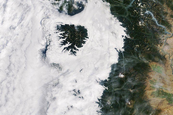
In mid-September 2026, a remarkable weather pattern blanketed the Pacific Northwest with a thick layer of clouds. Cool, marine air flowing off the Pacific Ocean created an impressive morning sky over western Washington and Oregon. This layer of clouds stretched across the region, with low-lying stratus clouds and fog reaching inland as far as the western foothills of the Cascade Range. At the same time, the tall peaks of the Olympic Mountains and the Oregon Coast Range appeared like islands protruding above the cloud layer, adding a scenic touch to the landscape.
This weather phenomenon was captured by NASA’s Terra satellite, which uses the MODIS sensor—short for Moderate Resolution Imaging Spectroradiometer. On September 19, 2026, around 10:45 a.m. Pacific Time, NASA’s imagery showed extensive cloud coverage over land and off the coast. Off the shores, the Pacific Ocean remained largely covered with clouds, while smoke from wildfires filled valleys in the North Cascades, adding a layer of haziness to the scene.
How Marine Clouds Form and Persist
For several nights, the National Weather Service noted a steady flow of marine air moving onshore. This moist, cool air traps itself beneath warmer layers of air in a phenomenon called a temperature inversion. When this occurs, the moisture near the surface cools enough for water vapor to condense, forming clouds. These low-level clouds, known as marine stratus, often linger over the region for days under consistent conditions.
On September 19, the strong surge of marine air created widespread cloud cover. Many areas experienced foggy conditions, with clouds extending down to the ground. This created a thick, gray morning that gave way in the afternoon to clearer skies in many places. When NASA’s Aqua satellite passed over the region around 4:15 p.m. Pacific Time, much of the area had cleared, though some clouds stayed along the Oregon coast where the temperatures remained cooler.
NASA’s Earth Observatory, through imagery and data, helps us understand these cloud patterns. The scene from space shows how natural atmospheric conditions can produce dynamic and picturesque weather, shaping the landscape and affecting daily life.
This weather pattern underscores the Pacific Northwest’s unique climate, where marine influences often dominate, creating a mix of fog, clouds, and clear skies. While this can bring cool, damp days, it also plays a role in local ecosystems, weather cycles, and the overall environment of the region.
Sources include NASA Earth Observatory, the National Weather Service, and academic research on regional cloud patterns, which help explain the science behind these atmospheric phenomena.
Continue Your Tech Journey
Stay informed on the revolutionary breakthroughs in Quantum Computing research.
Stay inspired by the vast knowledge available on Wikipedia.
Space
