

Summary Points
- Dry thunderstorms triggered thousands of lightning strikes across Oregon and Washington.
- Wildfires quickly spread, fueled by drought and strong winds.
- Over 10,000 firefighters battled blazes threatening communities across Oregon.
- By July 27, Oregon fires consumed over one million acres.
Smoke Blankets Oregon – NASA Science
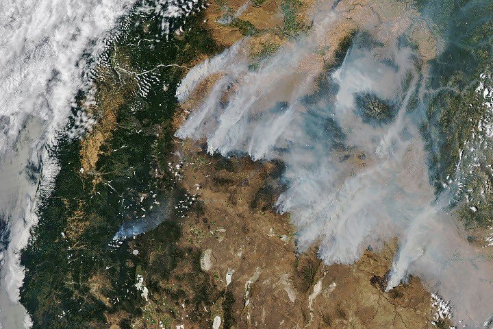
Dry thunderstorms moved over the Cascade Range on the evening of July 15, 2026. These storms unleashed thousands of lightning strikes across Oregon and Washington. The following day, NASA satellites began detecting an alarming number of wildfires in central and eastern Oregon.
Initially small, these fires expanded quickly. Gusty winds and extreme drought conditions intensified the blazes. By July 26, NASA’s Aqua satellite captured a striking image of the smoke pouring northeast from various large fires, covering hundreds of square miles. This resulted in air quality advisories for eastern Oregon, where many communities faced evacuation orders. Over 10,000 firefighters were deployed to combat the flames, tackling major active fires like the Hay Creek Complex and the Big Grass Fire. Many of these incidents were less than 5 percent contained, prompting the invocation of Oregon’s Emergency Conflagration Act to safeguard vulnerable communities.
Monitoring Wildfire Behavior
NASA’s technology plays a crucial role in wildfire monitoring and management. Government satellite data form part of a global observation system designed to track fire behavior and identify emerging trends. Real-time wildfire monitoring tools such as the Fire Information for Resource Management System (FIRMS) and Worldview are invaluable resources. These platforms assist in visualizing fire spread, which is critical for effective response and resource allocation.
As of July 27, 2026, more than one million acres in Oregon had been scorched. The National Interagency Fire Center reported that over four million acres were burning across the United States. This figure starkly contrasts with the 10-year average of 3.4 million acres for that point in the season (2016-2025). Access to timely satellite data enables emergency responders to track ongoing wildfires, helping to inform both operational strategies and community safety measures.
While technology offers significant advantages in monitoring fires, it also raises practical questions. Balancing the cost of advanced satellite systems against immediate needs in wildfire management is essential. However, the insights gained through these technological additions can improve response times and ultimately save lives. Understanding how to leverage NASA’s data effectively is vital for enhancing our preparedness for future wildfire seasons.
Expand Your Tech Knowledge
Explore the future of technology with our detailed insights on Artificial Intelligence.
Stay inspired by the vast knowledge available on Wikipedia.
Space
