

Summary Points
- Heavy rains caused widespread flooding and landslides in Nepal’s Lumbini and Gandaki.
- Gandak River reached record high levels, breaching embankments and inundating villages.
- Satellite images show extensive floodwaters, damaging farmland and displacing thousands.
- Authorities and relief teams respond to the severe floods and record water levels.
Rains Swamp the Gandak River
From September 24 to 27, heavy storms drenched Nepal’s mountainous Lumbini and Gandaki provinces. The intense rain came late in the monsoon season. It caused landslides and made the Gandak River, also called the Narayani, rise to record levels. This flooding affected both Nepal and India, damaging farmland, settlements, and displacing thousands.
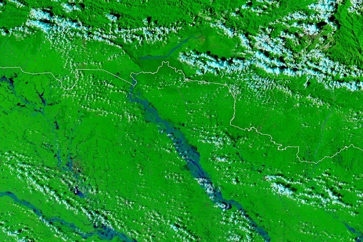
Satellite images by NASA’s MODIS sensors show the extent of the flooding. On September 20, 2026, images reveal a region still recovering from the storms. By September 29, the floodwaters had spread farther. These images use infrared and visible light to show water clearly. Floodwater appears bright blue, while green areas are healthy vegetation. Clouds are light blue.
### Impact of the Flooding and the Rising Waters
Much of the flooding happened in low-lying areas called diara—seasonal fields on sand and silt deposits within the river’s channel. These areas often flood during heavy rains. But this time, the water also broke through embankments built to hold back the river. Several settlements, including parts of Bagaha, Areraj, and Fulia Khand, were flooded. Authorities struggled to calculate the full damage.
Data from Nepal’s Department of Hydrology and Meteorology shows that the Devghāṭ gauge reached 11.94 meters on September 27. That is the highest level since measurements started in the 1960s. In India, gauges in Bagaha, Dumariaghat, Rewaghat, and Lalganj also hit record high-water marks. The flood pushed water to dangerous levels across the region.
The Gandak’s swelling also reached a new peak in Bihar, India. On September 29, the Gandak River’s water level at Bagaha reached 91.25 meters. Rising waters broke embankments in places like Saran and Muzaffarpur. Relief operations, including aid from the Indian Air Force, began quickly to help those affected.
NASA’s tools and datasets help track these extreme events. Resources such as Worldview, FLOOD Viewer, and GPM IMERG Global Viewer provide real-time data. These tools support officials and scientists in understanding flood patterns and planning responses.
Numerous reports confirm the widespread nature of this flood event. Local news outlets described panic and difficulty in Nepal’s Tarai region and Bihar, India. Villages were inundated, and roads became impassable. Thousands of people were displaced or stranded. Officials continue to assess the damage and coordinate relief efforts.
While technology offers critical support for flood monitoring, practical measures like improving embankments and early warning systems remain essential. Combining advanced technology with local knowledge can improve preparedness and response. Floods like these highlight the importance of resilient infrastructure and adaptive strategies for vulnerable regions.
Images and data from NASA provide a clear picture of the flood’s scope and impact. By monitoring such events in real time, authorities can respond more effectively and support affected communities.
Continue Your Tech Journey
Learn how the Internet of Things (IoT) is transforming everyday life.
Explore past and present digital transformations on the Internet Archive.
Space
