

Fast Facts
Hurricane Polo rapidly intensified off Mexico’s Pacific coast in September 2026.
It achieved record-breaking speeds, becoming a Category 5 storm swiftly.
Warm ocean waters and ideal atmospheric conditions fueled Polo’s explosive growth.
Experts emphasize climate patterns like El Niño increased overall cyclone activity.
Explosive Intensification for Hurricane Polo
In September 2026, Hurricane Polo emerged off the Pacific coast of Mexico. It started as a small tropical disturbance, but it quickly grew into a powerful storm. By September 20, it had become a tropical depression. The next day, it strengthened into a tropical storm. But the real story began when Polo entered a period of what meteorologists call “explosive intensification.”
This rapid strengthening shocked many weather experts. Some described the storm’s growth as “jaw-dropping,” “astonishing,” and even “absolute insanity.” Gary Partyka, an atmospheric scientist at NASA’s Goddard Space Flight Center, said Polo went through “explosively rapid intensification.” He emphasized that this was a case of “rapid, rapid intensification,” meaning the storm’s winds increased very quickly over a short time.
The environment around Polo was ideal for strengthening. Conditions included weak wind shear, high moisture levels, warmer ocean waters, and high atmospheric instability. Such factors help storms to grow stronger quickly.
< h3>How Rapid Was the Growth?
Extreme rapid intensification is a technical term that means a storm’s wind speeds increase by at least 60 knots (about 69 miles per hour or 111 kilometers per hour) within 24 hours. In Polo’s case, winds surged by 90 knots in this period—making it one of the fastest intensifications on record. By September 22, Polo had reached Category 5 strength, with maximum wind speeds near 285 kilometers per hour (about 180 miles per hour). This made it the third-strongest storm in the eastern Pacific by wind speed.
The National Hurricane Center called the storm’s rapid growth “truly remarkable.” Researchers flying NOAA’s Hurricane Hunter aircraft observed wind speeds close to the ceiling—about 285 km/h—during their overflight. That level of wind speed is rare and places Polo among the most intense storms in recent history.
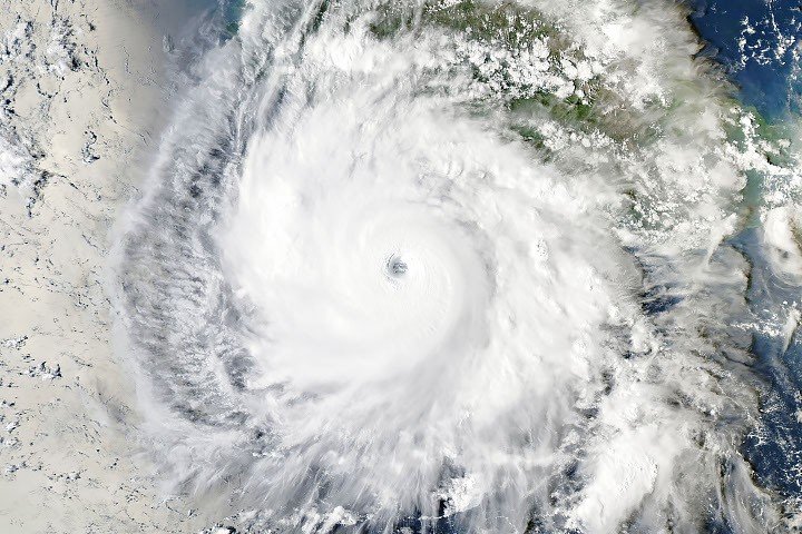
On September 23, satellite images captured Polo watching from off the coast of Guerrero, southwest of Acapulco. The storm’s eye was large and well-defined, with outflow patterns indicating strong upper-level winds. At that point, Polo was a Category 4 storm, with maximum sustained winds of 230 km/h (about 145 mph). It had recently experienced an eyewall replacement cycle, which temporarily weakened the storm.
< h3>The Role of Warm Ocean Waters
Polo’s explosive growth was fueled by very warm ocean waters. Sea surface temperatures reached as high as 32°C (90°F)—about 2 to 3 degrees warmer than normal for late September. Most hurricanes need water temperatures above 27.8°C (82°F) to maintain their strength.
Using data from NASA’s Multiscale Ultrahigh Resolution Sea Surface Temperature (MUR SST) project, scientists found that the water beneath Polo was not only warm at the surface but also hot at greater depths. This deep warmth provided the storm with a continuous supply of energy, helping it stay intense longer.
The warm water condition was not solely responsible for Polo’s sudden strength, but it played a major role. Usually, storms churn up cooler water in their wake, which can slow down their intensification. However, Polo did not seem to create this cooling effect. Observations show that the ocean heat content remained high at deeper levels beneath the storm, giving it plenty of fuel.
Experts say that while El Niño conditions—characterized by warmer-than-normal sea surfaces—can lead to increased hurricane activity in the eastern Pacific, they do not directly cause rapid intensification. Past storms like Hurricane Otis in 2023 and Patricia in 2015 also intensified quickly during different ocean conditions. Still, broader climate patterns do influence the overall pace of the season.
As of late September 2026, data indicated that overall cyclone activity in the eastern Pacific was nearly twice the normal level, supporting a more volatile hurricane season. Forecast models suggest Polo will stay over open waters for a while, then possibly turn northeast toward Baja California.
NASA’s satellite tools, including the Worldview browser, help scientists track sea surface temperature anomalies and storm behavior in near real-time. These observations are crucial for understanding how and why storms like Polo undergo such extreme changes in strength.
The explosive power of Hurricane Polo exemplifies how rapidly tropical cyclones can develop under the right conditions. While ocean warmth is a key ingredient, other atmospheric factors also contribute to such extraordinary intensification moments.
Continue Your Tech Journey
Dive deeper into the world of Cryptocurrency and its impact on global finance.
Discover archived knowledge and digital history on the Internet Archive.
Space
