

Quick Takeaways
Severe El Niño drought fueled widespread fires across New Guinea in 2026.
Smoke pollution disrupted flights, closed schools, and threatened vulnerable residents’ health.
Fires released record emissions, especially across Papua New Guinea and Indonesian Papua.
Human land-clearing fires spread uncontrollably; burning may persist until seasonal rains arrive.
Fires Char New Guinea as Drought and El Niño Intensify
New Guinea is the world’s second-largest island and one of its most ecologically varied. Seasonally dry savannas, tropical rainforests and lowland swamp forests all shape its landscapes. But during September and October 2026, drought and a strong El Niño helped fuel fires across the island. Smoke lingered for weeks.
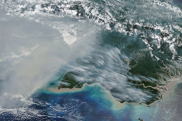
A VIIRS instrument aboard the NOAA-20 satellite captured thick smoke streaming from southern New Guinea on Oct. 11. The image shows the scale of the haze, but its effects were felt on the ground: Pollution disrupted flights, closed schools and led officials in some areas to advise children and older people to wear masks.
Drought primes the landscape to burn
El Niño shifts rainfall patterns, and this year’s unusually dry conditions left vegetation vulnerable to fire. In Papua New Guinea’s southern Trans-Fly region, the national weather service reported more than 90 consecutive days without rain. Parts of the region received only about 5% to 10% of normal precipitation from August onward. Local reports described crop failures, water shortages and school disruptions.
People ignite most fires in this normally wet part of the world, researchers say. They burn vegetation to clear land, maintain pastures, prepare fields and hunt. When conditions are dry, fires set for these purposes can escape control and spread, especially across the island’s drier southern areas.
The smoke creates risks beyond the burn areas. Some can mix with thunderstorm updrafts and rise into the upper atmosphere, or rain can wash it out. But much remains close to the surface, where it can worsen air quality. That exposure has made an already difficult fire season a public health concern.
Satellite estimates show exceptional fire activity
The Global Fire Emissions Database, or GFED, estimates fire activity and emissions by combining satellite observations with vegetation data and other information. Its estimates showed that fires in Papua New Guinea had released nearly 32 million metric tons of carbon by Oct. 17 — more than in any other year at that point in the record. Emissions had already exceeded the country’s full-year 2015 total, and researchers said 2026 could surpass 1997, another severe fire year.
On the Indonesian side of the island, often called Indonesian Papua or West New Guinea, estimated emissions exceeded 35 million metric tons of carbon. That ranked behind only 2015 and 1997, both years marked by severe fires during El Niño conditions.
These figures help researchers compare fire seasons across large, remote areas. But GFED provides modeled estimates, not a direct count of every fire or a measurement of every plume. Satellite monitoring can show where smoke and heat are detected; local reports and ground observations remain important for understanding impacts and guiding response.
Fire activity has also unfolded alongside forest loss. Over the past two decades, land in Indonesian Papua has been cleared for plantations, small-scale cultivation, urban growth and mining. Global Forest Watch reported that the region lost 27,000 hectares of primary forest in 2025, nearly twice the 2024 figure and its highest annual loss since 2017. Researchers have described Papua as an emerging deforestation frontier.
Land use can shape fire risk. In parts of Indonesia with large plantations, companies may maintain private firefighting crews to protect their assets. Fires can be harder to contain in unmanaged areas and along the edges of primary forest, where access may be limited. Those differences help explain why fire activity varies across the region, even during the same drought.
NASA and other satellite-based monitoring systems give officials and researchers timely information across vast areas. They can help identify active fires, track smoke and compare emissions over time. They cannot replace local firefighting capacity, health services or reliable reports from communities. Their value depends on how quickly observations reach people who can act on them.
Researchers expect fires to persist until the wet season brings heavy rain to southern New Guinea, typically in early November. Until then, drought, land-clearing practices and difficult access could continue to challenge fire response and prolong the smoke.
Expand Your Tech Knowledge
Stay informed on the revolutionary breakthroughs in Quantum Computing research.
Explore past and present digital transformations on the Internet Archive.
Space
