

Summary Points
- Hurricane Isaias struck Florida as a Category 2 storm on October 9.
- Its remnants intensified explosively, with pressure plunging over 50 hectopascals within 24 hours.
- Iceland’s cyclone may have broken its October pressure record from 1963.
- Hurricane-force winds, snow, and severe gusts disrupted Iceland and Scottish ferry services.
Extratropical Cyclone Whips Past Iceland
Hurricane Isaias made landfall in Florida as a Category 2 storm on Oct. 9, 2026, then brought rain and wind to the U.S. Gulf Coast and much of the Eastern Seaboard. Its journey did not end there. As the system moved east across the North Atlantic, it changed into a powerful extratropical cyclone and swept past Iceland.
From hurricane to North Atlantic powerhouse
Tropical hurricanes draw much of their energy from warm ocean water. Extratropical cyclones form and intensify through contrasts between warm and cold air, often along the jet stream. As a hurricane moves into cooler waters and interacts with larger weather systems, it can lose its tropical structure and become extratropical. The change does not necessarily make the storm weaker. These systems can still bring hurricane-force winds, heavy rain and, in colder areas, snow or sleet.
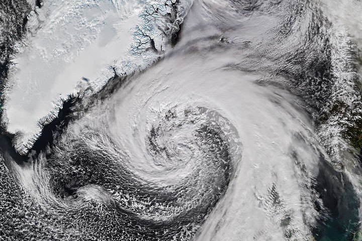
On the afternoon of Oct. 14, the VIIRS instrument aboard the NOAA-21 satellite captured the cyclone as it brushed Iceland. The image showed the broad, comma-shaped cloud pattern typical of many large low-pressure systems.
Satellite imagery gives forecasters a wide view of a storm’s shape and movement, including over remote ocean areas where observations are sparse. But an image alone cannot establish surface wind speeds or confirm the pressure at a particular location. Forecasters combine satellite data with weather-station readings, pressure measurements and other observations to assess a storm’s strength and likely effects.
Reports said the cyclone’s air pressure fell by more than 50 hectopascals in 24 hours. That is about twice the pressure drop used to define explosive cyclogenesis, also called bombogenesis. The term describes an unusually rapid strengthening of a low-pressure system. The threshold varies with latitude, but it is commonly defined as a pressure fall of at least 24 hectopascals in 24 hours at 60 degrees latitude.
Some meteorologists said the storm may also have set a new October low for barometric pressure in Iceland after accounting for altitude. If confirmed, it would break a record dating to 1963. The qualification matters: pressure readings taken at different elevations must be adjusted before researchers can compare them fairly.
Iceland feels the storm’s full force
The cyclone grazed Iceland but still delivered severe winds. A gust of 205 kilometers per hour (128 mph) was recorded near Eyjafjallajökull volcano in the south. A small island just offshore recorded sustained winds of 150 kilometers per hour (93 mph). Damaging winds also reached northern parts of the country, where residents prepared for sleet and snow.
The storm’s reach extended across the North Atlantic. Northwestern Scotland recorded gusts of up to 90 kilometers per hour (55 mph) on Oct. 14, according to news reports. Several ferry routes were canceled, disrupting travel as the weather system moved through.
The event highlights both the value and limits of satellite monitoring. Instruments such as VIIRS can track expansive storms and supply timely imagery that supports forecasting. Yet practical warnings still depend on combining those views with local measurements and reports. Satellite data show where a storm is and how its cloud structure is changing; observations on the ground help reveal what people and infrastructure are experiencing.
NASA Earth Observatory imagery used VIIRS data from NASA’s Earth Observing System Data and Information System and the Joint Polar Satellite System.
Stay Ahead with the Latest Tech Trends
Explore the future of technology with our detailed insights on Artificial Intelligence.
Access comprehensive resources on technology by visiting Wikipedia.
Space
