

Fast Facts
- Super Typhoon Bavi struck the Northern Mariana Islands and Guam in July 2026.
- Bavi reached peak winds of 290 km/h, causing extensive damage.
- Coast Guard cleared hazards and reopened ports after the storm’s passing.
- Meteorologist predicts more intense storms due to a strong El Niño.
Super Typhoon Bavi: A NASA Science Perspective
In early July 2026, Super Typhoon Bavi made headlines as it swept across the U.S. Northern Mariana Islands and Guam. This remarkable storm reached peak intensity just after midnight local time on July 6, packing winds of 290 kilometers (180 miles) per hour. The combination of fierce winds, torrential rain, and dangerous storm surges brought significant devastation to the area.
The Formation and Impact of Bavi
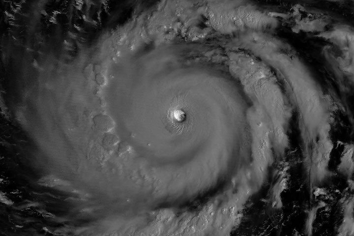
Bavi transformed into a super typhoon in the early hours of July 4, fueled by warm ocean waters, with surface temperatures around 30 degrees Celsius (86 degrees Fahrenheit). Satellite imagery from the VIIRS on the NOAA-20 satellite provided stunning nighttime views of the storm, capturing the eye of Bavi as it approached Rota. The image illustrated the storm’s massive structure, with the western eyewall illuminated by moonlight.
Impacts on the islands were severe. Reports indicated extensive damage as Bavi downed power lines and trees, disrupted transportation by flooding roads, and damaged critical infrastructure, including a water distribution station on Rota. The U.S. Coast Guard quickly mobilized to clear navigation hazards, ensuring safety as marine conditions began to improve. This disaster followed the recent effects of Super Typhoon Sinlaku, which swept through the region just three months earlier.
Future Projections and Climate Context
As of July 8, Bavi continued its journey westward over the Philippine Sea with maximum sustained winds of 250 kilometers (155 miles) per hour. Weather forecasts suggested that the storm could veer northwest toward Taiwan and southern Japan, with expectations of weakening in the following days. Meteorologist Jeff Masters from Yale Climate Connections noted that Bavi’s intensity aligns with patterns emerging during strong El Niño events. This phenomenon tends to allow typhoons to form further east, giving them more time to strengthen before making landfall.
Bavi serves as a stark reminder of the increasing intensity of tropical cyclones amid changing climate conditions. As research continues, the focus remains on understanding these storms and improving forecasting techniques. The technological advancements made in satellite imaging and data collection by agencies like NASA play a crucial role in monitoring and predicting the paths of such powerful storms. Enhanced awareness and preparedness could mitigate future impacts on vulnerable regions.
Through continuous observation and research, the science community aims to improve our understanding of storms like Super Typhoon Bavi. By leveraging advanced technology, we can better prepare for the challenges posed by nature’s most powerful forces.
Expand Your Tech Knowledge
Stay informed on the revolutionary breakthroughs in Quantum Computing research.
Explore past and present digital transformations on the Internet Archive.
Space
